through the pedestrian zone of S-Bad Cannstatt (Part 2) circular route from Stuttgart went in the post from 10/15/2010, it is the first part of the walk through the pedestrian area of Stuttgart-Bad Cannstatt. Today is the second part of the series. This is the area west and south of Market Street. starting point for the walk can be the station Bad Cannstatt, a train station, whose fate now in the weeks and months is completely open. If the Stuttgart 21 project realized, would the station Bad Cannstatt, after all, the station's largest Stuttgart city district in importance . Lose Many trains calling there today, would then pass to Bad Cannstatt. However, an alternative approach would met, such as the development of the Stuttgart etappierbare head station, would the station Bad Cannstatt before a great future. Then that station would be not only a hub for many regional trains. The new airport express train then held in Bad Cannstatt, before deciding on the Neckar valley and a tunnel from the east reached the airport's existing station. Yes, it would be in a later stage of development, even possible that ICE stopped on a direct connection between the North Station and the railway station Bad Cannstatt Bad Cannstatt. More expansion of the rail junction Stuttgart on recent developments there are on my blog http://s21irrtum.blogspot.com Leaving the station Bad Cannstatt through the main exit and continue straight in the Bahnhofstrasse, which is is a pedestrian zone.  |
| This work of art (large sculpture "rail pile, built in 1985) is located between the station and the pedestrian area of Bad Cannstatt rail road. |
At the end of the railway crosses the road a bit confusing Wilhelmsplatz using the pedestrian lights and finds out in the market street. 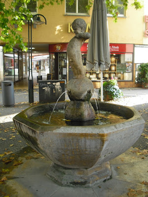 |
| in the market street to get to the peas well. Former Federal President Richard von Weizsacker has even said that he had once stood for the little boy on the fountain model. |
One market road continues to the end.  |
| The building was built in 1977 attempted Market Street No. 59, to fit into the historic architecture of the market street. These include the gabled design, the eaves, the roof outline and projections of the equipment at each floor. |
At the end of Market Street one turns left and goes over the Thaddeus-Troll place to Klösterle.  |
| The 1463 was built in 1982-84 and renovated Klösterle is considered the oldest residential building in Stuttgart. |
From Klösterle you go to the south continue to pedestrian reserved areas and reached after a short time the Brählesgasse.  |
| The Brählesgasse offers almost more historic buildings than the market street. |
About Brählesgasse you can get back on the market street. Then you go through but the Brählesgasse back and then keep to the south to the alley peas well. There it is left to the market street. In the market street one turns to the right. The additional right turn lanes are also worth exploring. Among them is the Felgergasse the Felgerhof.
 |
| Felgerhof When you see a group of the former city wall of Bad Cannstatt. |
Now it goes back to William Square, where it can continue to take the light rail. Or you can continue through the station road to the train station of Bad Cannstatt.


